Spatial distribution of air temperature at Cienfuegos province
Article Sidebar
Main Article Content
Abstract
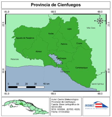
Knowledge of the spatial distribution of surface air temperature is of great value for the development of socioeconomic activities in countries that depend on climate, as a fundamental natural resource in the context of climate change. The mapping of air temperature in the Cienfuegos province is of practical importance because meteorological stations are few and unevenly distributed in the region. The present investigation has as objective: to determine the spatial distribution of the air temperature in the province of Cienfuegos. For the mapping of the temperature (mean, minimum and maximum) the monthly mean values of the normal period 1991-2020, from 62 meteorological stations, were used. A combination of linear regression statistical techniques was applied between the meteorological variable (air temperature) and geographical variables; and geostatistical techniques for interpolation of the results. The results of this research support that the most notable variations in the thermal field in the province are associated with the altitudinal zonality and the distance to the coast and the variation of the distribution by months in the periods (dry rainy and rainy).
Downloads
Article Details

This work is licensed under a Creative Commons Attribution-NonCommercial 4.0 International License.
Those authors who have publications with this journal accept the following terms of the License Attribution-NonCommercial 4.0 International (CC BY-NC 4.0):
You are free to:
- Share — copy and redistribute the material in any medium or format
- Adapt — remix, transform, and build upon the material
The licensor cannot revoke these freedoms as long as you follow the license terms.
Under the following terms:
- Attribution — You must give appropriate credit, provide a link to the license, and indicate if changes were made. You may do so in any reasonable manner, but not in any way that suggests the licensor endorses you or your use.
- NonCommercial — You may not use the material for commercial purposes.
- No additional restrictions — You may not apply legal terms or technological measures that legally restrict others from doing anything the license permits.
The journal is not responsible for the opinions and concepts expressed in the works, they are the sole responsibility of the authors. The Editor, with the assistance of the Editorial Committee, reserves the right to suggest or request advisable or necessary modifications. They are accepted to publish original scientific papers, research results of interest that have not been published or sent to another journal for the same purpose.
The mention of trademarks of equipment, instruments or specific materials is for identification purposes, and there is no promotional commitment in relation to them, neither by the authors nor by the publisher.
References
scapularis (Acari: Ixodidae) in nature: life cycle and study design implications. Journal of Medical Entomology, 33(4), 619-627.
Castillo, C. S., & Barcia, S. (2015). Sensaciones térmicas en la provincia Cienfuegos (Cuba). Investigaciones Geográficas, (64), 25-35. https://doi.org/10.14198/INGEO2015.64.02
Collins, F. C., & Bolstad. P. V. B., (1996) A comparison of spatial interpolation techniques in temperature estimation. In: Proceedings of the Third International Conference/Workshop on Integrating GIS and Environmental Modeling, January 21–26, 1996, Santa Barbara. (http://www.ncgia.ucsb.edu/conf/SANTA_FE_CD-OM/sf_papers/collins_fred/collins.html)
Connor, S. J., Thomson, M. C., Flasse, S. P., & Perryman, A. H. (1998). Environmental information systems in malaria risk mapping and epidemic forecasting. Disasters, 22(1), 39-56.
Courault, D., & Monestiez, P., (1999) Spatial interpolation of air temperature according to atmospheric circulation patterns in southeast France. International Journal of Climatology, 19: 365–378.
Delgado, R. & Peña, A. (2019). Cartografía de variables climáticas basada en gradientes, sistemas de expertos y SIG. Revista Cubana de Meteorología, 25(2). http://rcm.insmet.cu/index.php/rcm/article/view/464/685Fernández, F. (2008). Creación de nuevos mapas a partir del MDE. Aplicación de las funciones de análisis de superficies. In A. Moreno Jiménez (Coord.), Sistemas y Análisis de la Información Geográfica: Manual de autoaprendizaje con ArcGIS (2nd. Ed. pp. 329-648). RA-MA.
Focks, D. A., Daniels, E., Haile, D. G., & Keesling, J. E. (1995). A simulation model of the epidemiology of urban dengue fever: literature analysis, model development, preliminary validation, and samples of simulation results. American Journal of Tropical Medicine and Hygiene, 53(5), 489-506.
Flasse, S., Stephenson, P., Hutchinson, P., & Walker, C. (1995, September). Direct use of Meteosat in veterinary applications. In Proceedings of the EUMETSAT Meteorological Satellite Data Users Conference: Polar Orbiting Systems (pp. 453-459).
Gardner, A. S., Sharp, M. J., Koerner, R. M. et al., 2009. Near-surface temperature lapse rates over Arctic glaciers and their implications for temperature downscaling. Journal of Climate 22(16): 4281–4298.
Goetz, S. J., Prince, S. D., & Small, J. (2000). Advances in satellite remote sensing of environmental variables for epidemiological applications. Advances in Parasitology, 47, 289-307.
Guler, M., Cemek, B. & Gunal, H. (2007). Assessment of some spatial climatic layers through GIS and statistical analysis techniques in Samsun Turkey. Meteorological Applications (14), 163-169. https://doi.org/10.1002/met.18
Holdaway, M. R., (1996) Spatial modeling and interpolation of monthly temperature using kriging. Climate Research, 6: 215–225.
Hudson, G., & Wackernagel, H. (1994). Mapping temperature using kriging with external drift: theory and an example from Scotland. International journal of Climatology, 14(1), 77-91.
IPCC (2001). Climate change 2001: The scientific basis. Contribution of Working Group I to the Third Assessment Report of the Intergovernmental Panel on Climate Change (pp. 881). Cambridge, United Kingdom: Cambridge University Press Retrieved from the World Wide Web:http://www.grida.no/publications/other/ipcc_tar/?src=/CLIMATE/IPCC_TAR/wg1/052.htm
Lecha, L. B., Paz, L. R., & Lapinel, B. (1994). El clima de Cuba. Sello Editorial Academia.
Li, X., Cheng, G. & Lu, L. (2005) Spatial Analysis of Air Temperature in the Qinghai-Tibet Plateau. Arctic, Antarctic, and Alpine Research. 37(2), 246-252. https://doi.org/10.1657/1523-0430(2005)037[0246:SAOATI]2.0.CO;2.
Luo, Z., Wahba, G., and Johnson, D. R., (1998) Spatial-temporal analysis of temperature using smoothing spline ANOVA. Journal of Climate, 11: 18–28.
Millán, A., & Lallana, V. (2017). Modelización espacial del régimen bioclimático medio en la Comunidad Autónoma de Madrid mediante la aplicación de la temperatura fisiológica equivalente (PET). Revista Mapping, 26(183), 20-29. http://revistamapping.com/wp-content/uploads/2017/09/Revista-MAPPING-183_A2.pdf
Mount, G. A., & Haile, D. G. (1989). Computer simulation of population dynamics of the American
dog tick (Acari: Ixodidae). Journal of medical entomology, 26(1), 60-76.
Ninyerola, M., Pons, X., & Roure, J. M. (2000). A methodological approach of climatological modelling of air temperature and precipitation through GIS techniques. International Journal of Climatology, 20(14). https://doi.org/10.1002/1097-0088(20001130)20:14<1823::AID-JOC566>3.0.CO;2-B
Ninyerola, M., Pons, X., & Roure, J. M. (2005). Atlas climático digital de la Península Ibérica. Metodología y aplicaciones en bioclimatología y geobotánica. Universitat Autònoma de Barcelona. http://opengis.uab.es/wms/iberia/pdf/acdpi.pdf
Ninyerola, M., Pons, X., & Roure, J. M. (2007). Objective air temperature mapping for the Iberian Peninsula using spatial interpolation and GIS. International Journal of Climatology, 27(9), 1231-1242. https://doi.org/10.1002/joc.1462
OMM. (2018). Guía de prácticas climatológicas. (Edición de 2018). https://library.wmo.int/doc_num.php?explnum_id=10027
Planos, E., Rivero, R., & Guevara, V. (2013). Impacto del Cambio Climático y Medidas de Adaptación en Cuba. Instituto de Meteorología, Agencia de Medio Ambiente, CITMA. http://repositorio.geotech.cu/jspui/bitstream/1234/2820/1/Impacto%20del%20Cambio%20Clim%C3%A1tico%20y%20Medidas%20de%20Adaptaci%C3%B3n%20en%20Cuba%20Introducci%C3%B3n.pdf
Qin, Y., Ren, G., Huang, Y., Zhang, P. & Wen, K. (2021). Application of geographically weighted regression model in the estimation of surface air temperature lapse rate. J. Geogr. Sci. 31(3), 389-402. https://doi.org/10.1007/s11442-021-1849-5
Richardson, A. D., Lee, X., & Friedland, A. J. (2004). Microclimatology of treeline spruce–fir forests in mountains of the northeastern United States. Agricultural and Forest Meteorology, 125(1), 53-66.
Rolland, C. (2003). Spatial and seasonal variations of air temperature lapse rates in Alpine regions. Journal of Climate, 16(7): 1032–1046.
Smith, W. L., Leslie, L. M., Diak, G. R., Goodman, B. M., Velden, C. S., Callan, G. M., & Wade,
G. S. (1988). The integration of meteorological satellite imagery and numerical dynamical forecast models. Philosophical Transactions of the Royal Society of London A: Mathematical, Physical and Engineering Sciences, 324(1579), 317-323.
Snell, S. E., Gopal, S., & Kaufmann, R. K., (2000) Spatial interpolation of surface air temperature using artificial neural networks: evaluating their use for downscaling GCMs. Journal of Climate, 13: 886–895.
Sneyers, R. (1990). On the Statistical Analysis of Series of Observations. WMO. https://library.wmo.int/doc_num.php?explnum_id=1065
Solano, O., R. Vázquez y M. E. Martin (2006): Estudio de la extensión superficial anual de la sequía agrícola en Cuba durante el periodo 1951-1990. Revista Cubana de Meteorología, 13(2), 41-52.
Szymanowski, M., Kryza, M. & Spallek, W. (2013). Regression-based air temperature spatial prediction models: an example from Poland. Meteologische Zeitschrift, 2(5), 577-585. https://doi.org/10.1127/0941-2948/2013/0440
Thomson, M. C., Connor, S. J., Milligan, P. J., & Flasse, S. P. (1996). The ecology of malarias seen from Earth-observation satellites. Annals of tropical medicine and parasitology, 90(3), 243-264.
Wang, M., He, G., Zhang, Z., Wang, G., Zhang, Z., Cao, X., Wu, Z. & Liu, X. (2017). Comparison of Spatial Interpolation and Regression Analysis Models for an Estimation of Monthly Near Surface Air Temperature in China. Remote Sensing, 9(12), 1278; https://doi.org/10.3390/rs9121278