Distribución espacial de la temperatura del aire en la provincia de Cienfuegos
Barra lateral del artículo
Contenido principal del artículo
Resumen
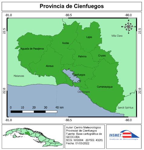
El conocimiento de la distribución espacial de la temperatura del aire superficial, es de gran valor para el desarrollo de las actividades socioeconómicas de los países que dependen del clima, como un recurso natural fundamental en el contexto del cambio climático. El mapeo de la temperatura del aire en la provincia de Cienfuegos es de importancia práctica porque las estaciones meteorológicas son escasas y están distribuidas de manera desigual en la región. La presente investigación tiene como objetivo: determinar la distribución espacial de la temperatura del aire en la provincia de Cienfuegos. Para la cartografía de la temperatura (media, mínima y máxima) se utilizaron los valores medios mensuales del período climático normal 1991-2020, de 62 estaciones meteorológicas. Se aplicó una combinación de técnicas estadísticas de regresión lineal entre la variable meteorológica (temperatura del aire) y variables geográficas; y técnicas geoestadísticas para la interpolación de los resultados. Los resultados de esta investigación avalan que las variaciones más notables en el campo térmico en la provincia están asociadas a la zonalidad altitudinal y la distancia a la costa y a la variación de la distribución por meses en los periodos (poco lluvioso y lluvioso).
Descargas
Detalles del artículo

Esta obra está bajo licencia internacional Creative Commons Reconocimiento-NoComercial 4.0.
Aquellos autores/as que tengan publicaciones con esta revista, aceptan los términos siguientes de la Licencia CC Reconocimiento-NoComercial 4.0 Internacional (CC BY-NC 4.0):
Usted es libre de:
- Compartir — copiar y redistribuir el material en cualquier medio o formato
- Adaptar — remezclar, transformar y crear a partir del material
El licenciador no puede revocar estas libertades mientras cumpla con los términos de la licencia.
Bajo las condiciones siguientes:
- Reconocimiento — Debe reconocer adecuadamente la autoría, proporcionar un enlace a la licencia e indicar si se han realizado cambios. Puede hacerlo de cualquier manera razonable, pero no de una manera que sugiera que tiene el apoyo del licenciador o lo recibe por el uso que hace.
- NoComercial — No puede utilizar el material para una finalidad comercial.
- No hay restricciones adicionales — No puede aplicar términos legales o medidas tecnológicas que legalmente restrinjan realizar aquello que la licencia permite.
La revista no se responsabiliza con las opiniones y conceptos emitidos en los trabajos, son de exclusiva responsabilidad de los autores. El Editor, con la asistencia del Comité de Editorial, se reserva el derecho de sugerir o solicitar modificaciones aconsejables o necesarias. Son aceptados para publicar trabajos científico originales, resultados de investigaciones de interés que no hayan sido publicados ni enviados a otra revista para ese mismo fin.
La mención de marcas comerciales de equipos, instrumentos o materiales específicos obedece a propósitos de identificación, no existiendo ningún compromiso promocional con relación a los mismos, ni por los autores ni por el editor.
Citas
scapularis (Acari: Ixodidae) in nature: life cycle and study design implications. Journal of Medical Entomology, 33(4), 619-627.
Castillo, C. S., & Barcia, S. (2015). Sensaciones térmicas en la provincia Cienfuegos (Cuba). Investigaciones Geográficas, (64), 25-35. https://doi.org/10.14198/INGEO2015.64.02
Collins, F. C., & Bolstad. P. V. B., (1996) A comparison of spatial interpolation techniques in temperature estimation. In: Proceedings of the Third International Conference/Workshop on Integrating GIS and Environmental Modeling, January 21–26, 1996, Santa Barbara. (http://www.ncgia.ucsb.edu/conf/SANTA_FE_CD-OM/sf_papers/collins_fred/collins.html)
Connor, S. J., Thomson, M. C., Flasse, S. P., & Perryman, A. H. (1998). Environmental information systems in malaria risk mapping and epidemic forecasting. Disasters, 22(1), 39-56.
Courault, D., & Monestiez, P., (1999) Spatial interpolation of air temperature according to atmospheric circulation patterns in southeast France. International Journal of Climatology, 19: 365–378.
Delgado, R. & Peña, A. (2019). Cartografía de variables climáticas basada en gradientes, sistemas de expertos y SIG. Revista Cubana de Meteorología, 25(2). http://rcm.insmet.cu/index.php/rcm/article/view/464/685Fernández, F. (2008). Creación de nuevos mapas a partir del MDE. Aplicación de las funciones de análisis de superficies. In A. Moreno Jiménez (Coord.), Sistemas y Análisis de la Información Geográfica: Manual de autoaprendizaje con ArcGIS (2nd. Ed. pp. 329-648). RA-MA.
Focks, D. A., Daniels, E., Haile, D. G., & Keesling, J. E. (1995). A simulation model of the epidemiology of urban dengue fever: literature analysis, model development, preliminary validation, and samples of simulation results. American Journal of Tropical Medicine and Hygiene, 53(5), 489-506.
Flasse, S., Stephenson, P., Hutchinson, P., & Walker, C. (1995, September). Direct use of Meteosat in veterinary applications. In Proceedings of the EUMETSAT Meteorological Satellite Data Users Conference: Polar Orbiting Systems (pp. 453-459).
Gardner, A. S., Sharp, M. J., Koerner, R. M. et al., 2009. Near-surface temperature lapse rates over Arctic glaciers and their implications for temperature downscaling. Journal of Climate 22(16): 4281–4298.
Goetz, S. J., Prince, S. D., & Small, J. (2000). Advances in satellite remote sensing of environmental variables for epidemiological applications. Advances in Parasitology, 47, 289-307.
Guler, M., Cemek, B. & Gunal, H. (2007). Assessment of some spatial climatic layers through GIS and statistical analysis techniques in Samsun Turkey. Meteorological Applications (14), 163-169. https://doi.org/10.1002/met.18
Holdaway, M. R., (1996) Spatial modeling and interpolation of monthly temperature using kriging. Climate Research, 6: 215–225.
Hudson, G., & Wackernagel, H. (1994). Mapping temperature using kriging with external drift: theory and an example from Scotland. International journal of Climatology, 14(1), 77-91.
IPCC (2001). Climate change 2001: The scientific basis. Contribution of Working Group I to the Third Assessment Report of the Intergovernmental Panel on Climate Change (pp. 881). Cambridge, United Kingdom: Cambridge University Press Retrieved from the World Wide Web:http://www.grida.no/publications/other/ipcc_tar/?src=/CLIMATE/IPCC_TAR/wg1/052.htm
Lecha, L. B., Paz, L. R., & Lapinel, B. (1994). El clima de Cuba. Sello Editorial Academia.
Li, X., Cheng, G. & Lu, L. (2005) Spatial Analysis of Air Temperature in the Qinghai-Tibet Plateau. Arctic, Antarctic, and Alpine Research. 37(2), 246-252. https://doi.org/10.1657/1523-0430(2005)037[0246:SAOATI]2.0.CO;2.
Luo, Z., Wahba, G., and Johnson, D. R., (1998) Spatial-temporal analysis of temperature using smoothing spline ANOVA. Journal of Climate, 11: 18–28.
Millán, A., & Lallana, V. (2017). Modelización espacial del régimen bioclimático medio en la Comunidad Autónoma de Madrid mediante la aplicación de la temperatura fisiológica equivalente (PET). Revista Mapping, 26(183), 20-29. http://revistamapping.com/wp-content/uploads/2017/09/Revista-MAPPING-183_A2.pdf
Mount, G. A., & Haile, D. G. (1989). Computer simulation of population dynamics of the American
dog tick (Acari: Ixodidae). Journal of medical entomology, 26(1), 60-76.
Ninyerola, M., Pons, X., & Roure, J. M. (2000). A methodological approach of climatological modelling of air temperature and precipitation through GIS techniques. International Journal of Climatology, 20(14). https://doi.org/10.1002/1097-0088(20001130)20:14<1823::AID-JOC566>3.0.CO;2-B
Ninyerola, M., Pons, X., & Roure, J. M. (2005). Atlas climático digital de la Península Ibérica. Metodología y aplicaciones en bioclimatología y geobotánica. Universitat Autònoma de Barcelona. http://opengis.uab.es/wms/iberia/pdf/acdpi.pdf
Ninyerola, M., Pons, X., & Roure, J. M. (2007). Objective air temperature mapping for the Iberian Peninsula using spatial interpolation and GIS. International Journal of Climatology, 27(9), 1231-1242. https://doi.org/10.1002/joc.1462
OMM. (2018). Guía de prácticas climatológicas. (Edición de 2018). https://library.wmo.int/doc_num.php?explnum_id=10027
Planos, E., Rivero, R., & Guevara, V. (2013). Impacto del Cambio Climático y Medidas de Adaptación en Cuba. Instituto de Meteorología, Agencia de Medio Ambiente, CITMA. http://repositorio.geotech.cu/jspui/bitstream/1234/2820/1/Impacto%20del%20Cambio%20Clim%C3%A1tico%20y%20Medidas%20de%20Adaptaci%C3%B3n%20en%20Cuba%20Introducci%C3%B3n.pdf
Qin, Y., Ren, G., Huang, Y., Zhang, P. & Wen, K. (2021). Application of geographically weighted regression model in the estimation of surface air temperature lapse rate. J. Geogr. Sci. 31(3), 389-402. https://doi.org/10.1007/s11442-021-1849-5
Richardson, A. D., Lee, X., & Friedland, A. J. (2004). Microclimatology of treeline spruce–fir forests in mountains of the northeastern United States. Agricultural and Forest Meteorology, 125(1), 53-66.
Rolland, C. (2003). Spatial and seasonal variations of air temperature lapse rates in Alpine regions. Journal of Climate, 16(7): 1032–1046.
Smith, W. L., Leslie, L. M., Diak, G. R., Goodman, B. M., Velden, C. S., Callan, G. M., & Wade,
G. S. (1988). The integration of meteorological satellite imagery and numerical dynamical forecast models. Philosophical Transactions of the Royal Society of London A: Mathematical, Physical and Engineering Sciences, 324(1579), 317-323.
Snell, S. E., Gopal, S., & Kaufmann, R. K., (2000) Spatial interpolation of surface air temperature using artificial neural networks: evaluating their use for downscaling GCMs. Journal of Climate, 13: 886–895.
Sneyers, R. (1990). On the Statistical Analysis of Series of Observations. WMO. https://library.wmo.int/doc_num.php?explnum_id=1065
Solano, O., R. Vázquez y M. E. Martin (2006): Estudio de la extensión superficial anual de la sequía agrícola en Cuba durante el periodo 1951-1990. Revista Cubana de Meteorología, 13(2), 41-52.
Szymanowski, M., Kryza, M. & Spallek, W. (2013). Regression-based air temperature spatial prediction models: an example from Poland. Meteologische Zeitschrift, 2(5), 577-585. https://doi.org/10.1127/0941-2948/2013/0440
Thomson, M. C., Connor, S. J., Milligan, P. J., & Flasse, S. P. (1996). The ecology of malarias seen from Earth-observation satellites. Annals of tropical medicine and parasitology, 90(3), 243-264.
Wang, M., He, G., Zhang, Z., Wang, G., Zhang, Z., Cao, X., Wu, Z. & Liu, X. (2017). Comparison of Spatial Interpolation and Regression Analysis Models for an Estimation of Monthly Near Surface Air Temperature in China. Remote Sensing, 9(12), 1278; https://doi.org/10.3390/rs9121278