Marine currents and water exchange on south of Artemisa, Cuba
Article Sidebar
Main Article Content
Abstract
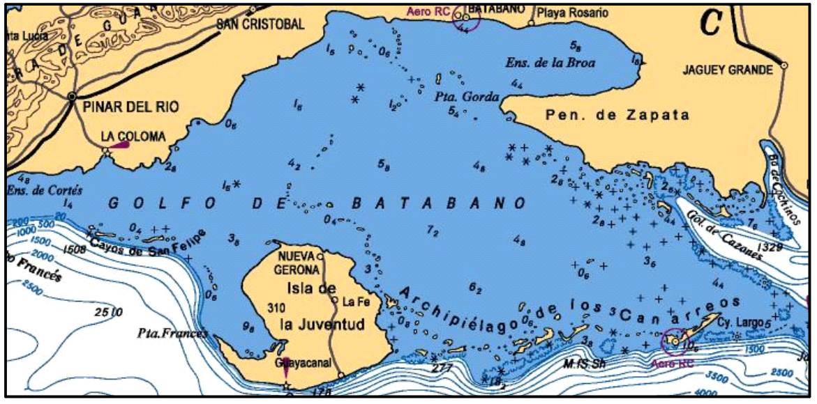
The coastal area located south of the Artemisa, part of the Gulf of Batabanó, is the area where the investigations were carried out. In January and July 2019, marine currents were measured in the main channels or rivers of this coastline; whose selection was made according to the criteria of the area's forest rangers, and the water flows through these exchange steps with the gulf were calculated. The marine currents in the Majana inlet, and south of Guanimar, Los 21 metros and Playa Cajío are slow, reaching extreme maximum magnitudes in the vicinity of Cajío, in July 2019. In Majana, currents with easterly directions dominate during both samplings, without significant influence of the tide; its influence is significant from Guanimar to Cajío. The direction of the estimated water flow through Maravilla, Los 21 metros, Guanimar and Cajío rivers coincided with the drainage or not of “Dique sur” speed bumps closest to each of these passes. The estimated volume of water entering the Cajío river in January 2019 is greater than that exiting in July 2019, during the rainy season of the year and with persistent rains during sampling; Therefore, in Cajío the saline intrusion could be systematically accelerated by the behavior of the coastal marine circulation; however, affirming this requires carrying out measurements for a longer period of time and including other points on the southern coast of Artemisa.
Downloads
Article Details

This work is licensed under a Creative Commons Attribution-NonCommercial 4.0 International License.
Those authors who have publications with this journal accept the following terms of the License Attribution-NonCommercial 4.0 International (CC BY-NC 4.0):
You are free to:
- Share — copy and redistribute the material in any medium or format
- Adapt — remix, transform, and build upon the material
The licensor cannot revoke these freedoms as long as you follow the license terms.
Under the following terms:
- Attribution — You must give appropriate credit, provide a link to the license, and indicate if changes were made. You may do so in any reasonable manner, but not in any way that suggests the licensor endorses you or your use.
- NonCommercial — You may not use the material for commercial purposes.
- No additional restrictions — You may not apply legal terms or technological measures that legally restrict others from doing anything the license permits.
The journal is not responsible for the opinions and concepts expressed in the works, they are the sole responsibility of the authors. The Editor, with the assistance of the Editorial Committee, reserves the right to suggest or request advisable or necessary modifications. They are accepted to publish original scientific papers, research results of interest that have not been published or sent to another journal for the same purpose.
The mention of trademarks of equipment, instruments or specific materials is for identification purposes, and there is no promotional commitment in relation to them, neither by the authors nor by the publisher.
References
Arriaza L., M. Hernández, L. Rodas y J. Simanca (2005): Simulación de la circulación en el Golfo de Batabanó II. Contribución a la educación y la protección ambiental Vol. 6, ISBN 959-7136-35-X.
Arriaza L., D. E. Milian, L. Rodas y J. Simanca (2006 a): A basis for Enviromental Monitoring in the Gulf of Batabanó applying hydrodynamic simulations, Contribution to the Education and Environmental Protection, Vol. 7, ISBN 979-7136-43-0.
Arriaza L., L. Rodas, J. Simanca, S. L. Lorenzo, D. E. Milian y P. Romero (2008): Contribución a la gestión ambiental del golfo de Batabanó: modelación numérica de corrientes marinas, Rev. Invest. Mar. No29, pp 89-99.
Blázquez L. (1981): Algunos aspectos del régimen de temperatura en la plataforma Noroccidental de Cuba y la región oceánica adyacente. Informe científico técnico No. 171. Instituto de Oceanología. ACC. La Habana, Cuba.
Blázquez L y E. Romeu (1982): Contribución al estudio de la circulación general del Golfo de Batabanó. Zona B. Reporte de Investigación. No 1. Instituto de Oceanología. ACC. La Habana, Cuba, 34 pp. 1-33.
Blázquez L, J. P. Rodríguez-Portal, I. Rosabal-Campos y R. Calderón Hebra (1988): Mediciones de corrientes marinas en el Golfo de Batabanó. Reporte de Investigación. No 14. Instituto de Oceanología. ACC. La Habana, Cuba, ISSN 0138-6328.
Emilsson I. y J. Tápanes (1971): Contribución a la hidrología de la plataforma Sur de Cuba. Serie Ocenológica. No 9. ACC.
García C., A. Betanzos, y J.A. Gómez (1995): Oceanografía del área de Punta del Este. Golfo de Batabanó, Cuba. Revista cubana de Investigaciones Pesqueras, CIP, Cuba, pp. 10-17.
González B., E. y E. Flores V. (2015): Avance de la intrusion salina originada por el ascenso del nivel medio del mar, escenario 2050. Macroproyecto cambio climático: "Escenarios de peligro y vulnerabilidad de la zona costera 2050-2100"
Hernández M., A. Hernández, L. Arriaza, J. Simanca, S. L. Lorenzo, S. Cerdeira, L. Rodas, G. Díaz, I. Hernández, O. Marzo, J. L. Chang, A. Oviedo y H. M. Alfonso (2005 a): Estimación de la tasa de incremento del nivel medio del mar a partir de mediciones directas y evaluación de su impacto en el Golfo de Batabanó y en la Península de Zapata. Proceedings de Geociencias 2005. Sociedad Cubana de Geología. 5 al 8 de abril del 2005. Palacio de las Convensiones. La Habana. Cuba. ISBN 959-7117-03-7.
Hernández M., L. Rodas, L. Arriaza, J. Simanca, S. L. Lorenzo, S. Cerdeira, E. O. Linares y A. Morales (2005 b): Características y pronóstico de la circulación de las aguas de las plataformas Suroccidental y Noroccidental y de su influencia sobre la distribución espacio – temporal de la temperatura y la salinidad mediante la modelación numérica. Informe de resultado del proyecto Desarrollo de métodos y tecnologías para el pronóstico de procesos oceanográficos en la plataforma insular cubana. Archivo Científico de la Agencia de Medio Ambiente (AMA), del Ministerio de Ciencia, Tecnología y Medio Ambiente de Cuba (CITMA). 160 pp.
Lluis M. (1972): Estudios hidrológicos del Golfo de Batabanó y de las aguas oceánicas adyacentes. Serie Oceanológica No. 14 y Rep. Invest. No 18. Instituto de Oceanología. ACC.
Lorenzo-Sánchez; Sergio L., L. Rodas; L. Arriaza; M. Hernández, A. Morales y J. Viamonte (2007 b): Espaciocartas sobre la circulación general de las aguas en las plataformas Noroccidental, Suroccidental y Suroriental de Cuba. Informática 2007. ISBN 978 959 285 002-5.
Rodas L., J. Navarro Padrón, R. García Santos y Y. Carrillo Betancourt (2015): “Corrientes marinas”. Informe al proyecto “Bases ambientales para la sostenibilidad alimentaria local (BASAL)”.
Rodríguez J. y J. Rodríguez (1983): Las mareas en las costas cubanas. Rep. Invest. No 8. Instituto de Oceanología. ACC.
Simanca J., A. Gómez y L. Fernández (1992): Corrientes Marinas al S de Cuba. II Congreso de Ciencias del Mar, MARCUBA.
Simanca J., O. Ramírez, L. Fernández (2003): Corrientes marinas al S del Golfo de Batabanó. V Congreso de Ciencias del Mar, MARCUBA.
Simanca J. (2004): Análisis de las Características Estadísticas y Espectrales de las Componentes Periódicas y no Periódicas de la Corriente Sumaria en la Periferia Acuática del Golfo de Batabanó, Tesis de maestría especialidad de Análisis Ambiental.
Simanca, J. L. Fernández, J. Viamontes, O. Ramírez y L. Arriaza (2005): Características estadísticas de las componentes periódicas y no periódicas de la corriente sumaria en el golfo de Batabanó. Rev. Contribución a la Educación y la Protección Ambiental. Vol. 6, ISBN 959-7136-35-X
Viamontes F.J. (1990): Carretera turística desde Punta del Este hasta Cayo Largo del Sur, Informe Científico - Técnico de las 1ra, 2da y 3ra etapas. Instituto Cubano de Hidrografía. Archivos de GEOCUBA, Estudios Marinos. La Habana, Cuba. 240 pp.