Design of a spatial data infrastructure, applied to mountain climatology in Cuba
Main Article Content
Abstract
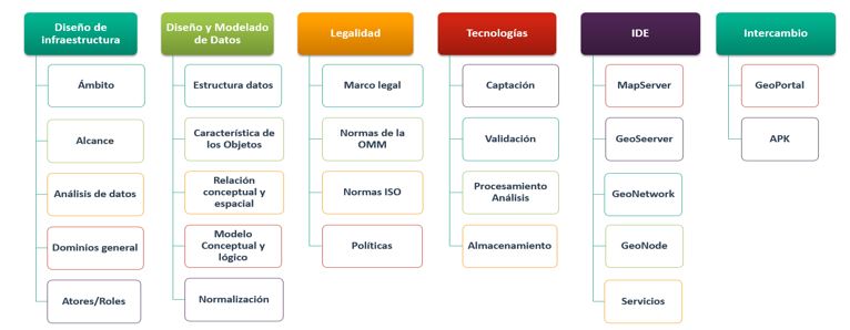
The present result proposes a design of a Spatial Data Infrastructure for mountain climatology, where the existing regulatory frameworks were examined in terms of national and international standards and norms. A proposal for a methodology for the design, development and modeling of data with its metadata was made. The client-server data management systems were detailed, using the CAP Theorem. It allowed to argue and propose a Spatial Data infrastructure design methodology and the best options for the Cuban context, promoting those of free programs and open source. The basic geospatial data services that must be provided and their spatial relationship were exposed, the roles assigned to each actor in the infrastructure were defined, including selecting maps, executing predefined queries, generating and exporting spatial products and reports, as well as modifying data. Security and integrity requirements were established for all stored information and good practices to be followed in public applications on the Internet, domain security and certification of web function services, minimum availability and access requirements were implemented. The best technological solutions for deployment, servers and clients for Spatial Data Infrastructures, desktops, spatial database management systems, data capture applications and cloud storage were proposed. Evaluation indicators were proposed that allow constant improvements.
Downloads
Article Details

This work is licensed under a Creative Commons Attribution-NonCommercial 4.0 International License.
Those authors who have publications with this journal accept the following terms of the License Attribution-NonCommercial 4.0 International (CC BY-NC 4.0):
You are free to:
- Share — copy and redistribute the material in any medium or format
- Adapt — remix, transform, and build upon the material
The licensor cannot revoke these freedoms as long as you follow the license terms.
Under the following terms:
- Attribution — You must give appropriate credit, provide a link to the license, and indicate if changes were made. You may do so in any reasonable manner, but not in any way that suggests the licensor endorses you or your use.
- NonCommercial — You may not use the material for commercial purposes.
- No additional restrictions — You may not apply legal terms or technological measures that legally restrict others from doing anything the license permits.
The journal is not responsible for the opinions and concepts expressed in the works, they are the sole responsibility of the authors. The Editor, with the assistance of the Editorial Committee, reserves the right to suggest or request advisable or necessary modifications. They are accepted to publish original scientific papers, research results of interest that have not been published or sent to another journal for the same purpose.
The mention of trademarks of equipment, instruments or specific materials is for identification purposes, and there is no promotional commitment in relation to them, neither by the authors nor by the publisher.
References
Coleman, D.J. and McLaughlin, J.D. (1997). Defining Global Geospatial Data Infrastructure (GGDI). www.gsdi.org
Delgado Fernández T. (2007). “Proyecto CYTED IDEDES “Evaluación y Potenciación de las IDEs en el desarrollo sostenible en América Latina y el Caribe”. http://redgeomatica.rediris.es/idedes/IDEs_en_Iberoamerica.pdf
Delgado, T., & Cruz, R. (2009). Construyendo Infraestructuras de Datos Espaciales a nivel local. CUJAE, La Habana, 130pp. https://www.researchgate.net/profile/Tatiana-Delgado/Construyendo-Infraestructuras-de-datos-espaciales-a-nivel-local.pdf
GeoNode. (2022). www.osgeo.org/projects/geonode/
GeoServer. (2022). http://geoserver.org/
González, M.J., & Lázaro, M.L. (2011). La geoinformación y su importancia para las tecnologías de la información geográfica. 148. http://www.ub.es/geocrit/aracne/aracne-148.htm
Hernández-Sampieri, R. & Mendoza, C. (2018). Metodología de la investigación. Las rutas cuantitativa, cualitativa y mixta. Editorial Mc Graw Hill Educación. Edición: 2018, ISBN: 978-1-4562-6096-5, 714 p. http://www.biblioteca.cij.gob.mx/Archivos/Materiales_de_consulta/Drogas_de_Abuso/Articulos/SampieriLasRutas.pdf
J.P. Bruce. (1994). Observando el medio ambiente mundial, Tiempo, clima y agua (OMM-Nº 796). Ginebra. https://library.wmo.int
Maganto, Alejandra & Nogueras-Iso, Javier & Ballari, Daniela. (2008). Normas sobre metadatos (ISO19115, ISO19115-2, ISO19139, ISO15836). Mapping, ISSN 1131-9100, Nº 123, 2008. La familia de normas ISO 19100). pags. 48-57. https://library.wmo.int
McLaughlin & Groot, Richard, J. (2000). Geospatial data infrastructure-concepts, cases and good practice. (pdf)
Muro-Medrano. P. (2012). Etapas de la popularización de las infraestructuras de información geoespacial. GeoFocus. Revista Internacional de Ciencia y Tecnología de la Información Geográfica 12, 1–5. http://geofocus.rediris.es/2012/Editorial_2012.pdf
OGC. (2004). Geospatial Portal Reference Architecture. OpenGIS®. Discussion paper. Version 0.2. Document OGC 04-039. http://www.opengis.org/.
OGC. (2006). Catalogue Services Specification 2.0.1. OpenGIS®. Application profile Version 1.0. Document OGC 04-038r4. http://www.opengis.org/.
Olle. Wiley, T. William. (1978). The Codasyl Approach to Data Base Management. ISBN 0-471-99579-7. (PDF)
Organización Internacional de Normalización. (2019). Geographic information-Metadata. (ISO 19115-2:2019(en). https://www.iso.org/obp/ui/#iso:std:iso:19115:-2:ed-2:v1:en
Organización Meteorológica Mundial. (1983). (1996). (2008). (2014). Guía de Instrumentos y Métodos de Observación Meteorológicos (OMM-Nº 8). quinta, sexta y séptima ediciones. Ginebra. https://library.wmo.int
Ortiz, Anita. (2015). Lenguaje de base de datos. www.slideshare.net/ralbarracin/lenguajes-de-bases-de-datos.
Piattini, M., & Marcos, E., De Miguel, A. (1999). Fundamentos y modelos de bases de datos, ed. Editorial Ra-Ma. (PDF)
Pombo, D. G. (2019). Conocimiento, acceso, derechos y democratización de los datos: Infraestructura de Datos Espaciales (IDE). Huellas, 23, 71-85. https://dialnet.unirioja.es/servlet/articulo?codigo=7043621
PostgreSQL. (2022). The world’s most advanced open source database. https://www.postgresql.org/
Roche, Stephane. (2014). “Geographic Information Science: Why does a smart city need to be spatially enabled?”, en Progress in Human Geography 1–9. (pdf)
Seth Gilbert, Lynch Nancy. (2002). Brewer‟s Conjecture and the Feasibility of Consistent, Available, Partition-Tolerant Web Services. http://lpd.epfl.ch/sgilbert/pubs/BrewersConjecture-SigAct.pdf
Tsou, M. H., & Yanow, K. (2010). Enhancing General Education with Geographic Information Science and Spatial Literacy. Journal of the Urban & Regional Information Systems Association. https://www.researchgate.net/profile/MingHsiang_Tsou/publication/236966170_Enhancing_General_Education_with_Geographic_Information_Science_and_Spatial_Literacy/links/0c96051a81cb6d9c34000000.pdf
WMO. (2000). Technical Conference on Meteorological and Environmental Instruments and Methods of Observation, Lightning Detection Systems (WMO/TD-No. 1028). Ginebra. https://library.wmo.int

