Assimilation of satellite observations in support of hydrocarbon fate forecasting in the Cuban EEZ
Article Sidebar
Main Article Content
Abstract
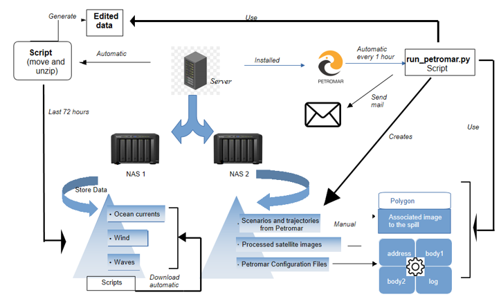
The initialization of the runs of the numerical model of lagrangian approach PETROMAR-3D, from SAR images, is shown. With this new feature, the model is prepared to give operational response to an oil pollution event in the seas around Cuba. The oil slick polygon outputs of the SeonSE Engine and SNAP-ESA satellite information processing tools were used, developing new functions and Python libraries in the PETROMAR-3D software. With this result, a semi-automatic oil slick surveillance and monitoring service was developed in the seas around Cuba, with the computer tools of satellite data processing and the PETROMAR-3D Lagrangian oil spill model. With this service, users receive the information through a first email from the moment the slick is detected, and then receive another one with the oil drift modeling map for 72 hours. For this purpose, a script was developed that runs automatically through a scheduled task in the operating system, and handles all the software applications of the system designed with new Python functions and libraries.
Downloads
Article Details

This work is licensed under a Creative Commons Attribution-NonCommercial 4.0 International License.
Those authors who have publications with this journal accept the following terms of the License Attribution-NonCommercial 4.0 International (CC BY-NC 4.0):
You are free to:
- Share — copy and redistribute the material in any medium or format
- Adapt — remix, transform, and build upon the material
The licensor cannot revoke these freedoms as long as you follow the license terms.
Under the following terms:
- Attribution — You must give appropriate credit, provide a link to the license, and indicate if changes were made. You may do so in any reasonable manner, but not in any way that suggests the licensor endorses you or your use.
- NonCommercial — You may not use the material for commercial purposes.
- No additional restrictions — You may not apply legal terms or technological measures that legally restrict others from doing anything the license permits.
The journal is not responsible for the opinions and concepts expressed in the works, they are the sole responsibility of the authors. The Editor, with the assistance of the Editorial Committee, reserves the right to suggest or request advisable or necessary modifications. They are accepted to publish original scientific papers, research results of interest that have not been published or sent to another journal for the same purpose.
The mention of trademarks of equipment, instruments or specific materials is for identification purposes, and there is no promotional commitment in relation to them, neither by the authors nor by the publisher.