Coastal sensitivity evaluation for the impact of hydrocarbons spills
Article Sidebar
Main Article Content
Abstract
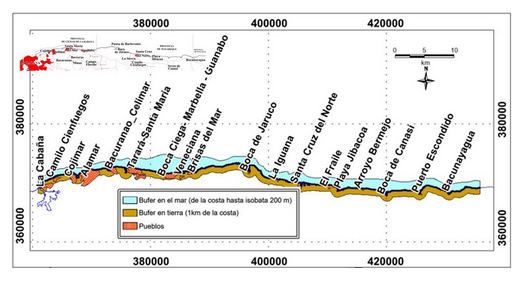
The Environmental Sensitivity Index (ISA) maps constitute a very useful computer tool for disaster surveillance and mitigation institutions, in situations of impacts of oil spills against the coastal zone. At a global level there are different procedures for its preparation, according to the standards created by the Asociación Regional de Empresas del Sector Petróleo, Gas y biocombustibles en Latinoamérica y el Caribe (ARPEL), la Canadian International Development Agency (CIDA), la Nacional Oceanic and Atmospheric Administration (NOAA), Petróleos Brasileiros S.A. (PETROBRAS). Each one responds to patterns of technological development, which do not correspond to Cuba's infrastructure. The objective of this project is to evaluate existing methodologies and create one of our own for Cuba. In this first stage tested for the coastal stretch from Havana Bay to the Bacunayagua inlet, an area known as the Northern Cuban Oil Strip (FPNC), where the main gas-oil deposits in Cuba and one of the largest maritime corridors for the transfer of oil are located. Hydrocarbons within the Strait of Florida. The evaluation included oceanological, geomorphological, sedimentological, economic, meteorological, environmental aspects, satellite image processing, mathematical modeling and other information of interest for the Cuban coastal area.
Downloads
Article Details

This work is licensed under a Creative Commons Attribution-NonCommercial 4.0 International License.
Those authors who have publications with this journal accept the following terms of the License Attribution-NonCommercial 4.0 International (CC BY-NC 4.0):
You are free to:
- Share — copy and redistribute the material in any medium or format
- Adapt — remix, transform, and build upon the material
The licensor cannot revoke these freedoms as long as you follow the license terms.
Under the following terms:
- Attribution — You must give appropriate credit, provide a link to the license, and indicate if changes were made. You may do so in any reasonable manner, but not in any way that suggests the licensor endorses you or your use.
- NonCommercial — You may not use the material for commercial purposes.
- No additional restrictions — You may not apply legal terms or technological measures that legally restrict others from doing anything the license permits.
The journal is not responsible for the opinions and concepts expressed in the works, they are the sole responsibility of the authors. The Editor, with the assistance of the Editorial Committee, reserves the right to suggest or request advisable or necessary modifications. They are accepted to publish original scientific papers, research results of interest that have not been published or sent to another journal for the same purpose.
The mention of trademarks of equipment, instruments or specific materials is for identification purposes, and there is no promotional commitment in relation to them, neither by the authors nor by the publisher.